Surrey Hills,
Victoria.
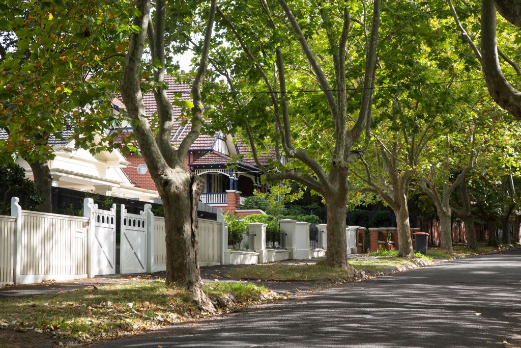
Federation homes, mature plane-lined streets, an 1880s heritage village strip, and two of Melbourne’s most sought-after secondary school zones.
Surrey Hills, Victoria. The definitive guide.
Surrey Hills (postcode 3127) is a residential suburb 11 km east of Melbourne CBD, located across the Cities of Boroondara and Whitehorse.
It is defined by Federation and Edwardian period homes on generous blocks, streets lined with mature plane and pin oak trees, and the heritage Union Road Commercial Precinct — a heritage-listed village shopping strip that has served the community since the 1880s.
The median house price was $2,100,000 for the June 2025 quarter (REIV). The suburb’s school precinct — Surrey Hills Primary, Canterbury Girls Secondary College zone, and proximity to Camberwell Grammar — is what brings most families here. Kylie Minogue and Dannii Minogue grew up in Surrey Hills.
The suburb sits at one of the highest points east of Melbourne’s CBD, giving many properties long northern views. In 2023, the Level Crossing Removal Project replaced the Surrey Hills and Mont Albert stations with the new Union Station.
Surrey Hills was named in 1878 by estate agent and councillor J.H. Knipe — borrowing the name from the English county of Surrey. The suburb took off in 1882 when the railway extended from Camberwell to Lilydale. Its housing stock shares the same tree-lined, period-home character that defines the inner eastern corridor.
Postcode 3127 key data:
- 11 km east of Melbourne CBD · Cities of Boroondara and Whitehorse
- Population approximately 13,655 (ABS 2021 Census)
- Median age 42 · predominant age group 50–59
- Median household weekly income $2,503
- Approximately 76.5% owner-occupied
- Train stations: Union Station (Belgrave/Lilydale lines), Chatham Station
- Tram routes 109 (Whitehorse Road) and 70 (Riversdale Road)
- Heritage strip: Union Road Commercial Precinct — listed 1980s
Fletchers Canterbury: 250 Canterbury Road Canterbury VIC 3126 · 03 9836 2222
What defines Surrey Hills
Surrey Hills offers most of what Canterbury offers — the school zones, the heritage homes, the tree-lined streets — at a lower entry price point. That gap has been narrowing for a decade, but it remains a primary draw for families.
Union Road is the suburb’s social centre. It predated the railway line and has served commuters for over 130 years. Today it is a destination of independent cafés, boutiques, homewares, and specialty food. The Surrey Hills Neighbourhood Centre, established in 1983, serves as a community anchor.
Quick suburb facts
- Postcode 3127 · Boroondara & WhitehorseInner eastern Melbourne
- $2,100,000 median house priceREIV June 2025 quarter
- 13+ years average hold periodTightly held residential market
- Canterbury Girls Secondary College ZoneSignificant property demand driver
- Heritage-listed Union Road stripOne of Melbourne’s oldest active retail precincts
- English Counties StreetsNorfolk, Durham, Kent, Middlesex, Essex, Suffolk
Surrey Hills property market. 2026 data.
The median house price in Surrey Hills, Victoria (postcode 3127) is approximately $2,100,000 for the June 2025 quarter (REIV). CoreLogic records the rolling 12-month median at approximately $2,265,000.
The auction clearance rate for houses is 69.9% and average days on market is 31 days (CoreLogic 2026). There were 161 house sales in the past 12 months. The median unit price is $950,000 (REIV, June 2025).
Rental yield for houses is approximately 2.0% with median weekly house rent at $850. Surrey Hills is a tightly held capital growth suburb, with owner-occupiers making up 76.5% of residents.
Surrey Hills operates as a capital growth market, not a yield market. The 2.0% rental yield tells you that buyers here are holding for the long term. Average hold periods across the suburb exceed 13 years — properties are not turning over quickly, supply is consistently tight, and demand is structural rather than speculative.
The school precinct is the primary demand engine. Families targeting Surrey Hills Primary’s catchment and the Canterbury Girls Secondary College zone consistently outbid comparable buyer profiles in adjacent suburbs. That dynamic has been consistent across multiple market cycles and shows no sign of changing.
The proximity to Canterbury — median house price $3,687,500 as of 2026 — at a $1.5M+ discount for equivalent period-home character is what continues to pull buyers across from the inner east. That gap has been the story of Surrey Hills for the past decade.
Union Road and Melbourne’s heritage village strip.
The Union Road Commercial Precinct has served Surrey Hills since the 1880s. It emerged alongside the railway station and has been the community’s social centre for over 130 years.
What it is and its history
Union Road predated the railway line. When the Lilydale extension reached Surrey Hills in October 1883, Union Road was briefly renamed Surrey Road before reverting to its original title by 1885. The commercial strip grew rapidly — the Surrey Family Hotel at the corner of Canterbury Road opened in 1888, and by the 1890s the precinct had its first general store, post office, banks, and tradespeople.
A second wave of development followed World War I. The ES&A Bank built premises in 1912. The State Savings Bank arrived in 1916. By 1930 the Commercial Bank of Australia had joined. The buildings constructed between the 1890s and 1920s — Classical Revival facades at the earlier end, simpler detailing in the interwar buildings — give the strip its architectural character today.
Most shopfronts at ground level retain their original or early form and the first-floor facades are largely intact. This intactness is rare in Melbourne — Union Road’s heritage value was formally recognised when the Union Road Commercial Precinct was listed under the Boroondara heritage overlay in the early 1980s.
Community Action
Today Union Road is home to independent cafés, specialty food, boutiques, florists, and the Surrey Hills Neighbourhood Centre at 157 Union Road. The Neighbourhood Centre itself has its own heritage story — it was built in 1983 after community action defeated a Country Roads Board plan to demolish the site for a road overpass.
The strip is also host to the annual Surrey Hills Music Festival, continuing its legacy as the central gathering point for the suburb.
The English Counties
Nearby, Surrey Hills contains the ‘English Counties District’, a small precinct between Canterbury and Riversdale Roads where streets are named after English Counties: Norfolk Road, Durham Road, Kent Road, Middlesex Road, Essex Road, and Suffolk Road. This area is highly sought after for its intact character and tree canopy.
Surrey Hills school precinct. A major buyer drawcard.
The school catchment zones are why buyers come. Canterbury Girls Secondary College zone coverage across much of postcode 3127 is the single most significant factor in competition at the $2M–$2.5M house price range.
Government primary schools: Surrey Hills Primary School (est. 1886) and Chatham Primary School. Our Lady of Perpetual Succour is the Catholic primary.
Government secondary: Canterbury Girls Secondary College (CGSC) — one of only five government all-girls secondary schools in Victoria — covers a significant portion of Surrey Hills in its designated neighbourhood zone. Camberwell High School is also accessible.
Private schools nearby: Camberwell Grammar School (boys, est. 1886), Camberwell Girls Grammar School (est. 1920), Kingswood College on Station Street, and Fintona Girls School.
Always verify current catchment boundaries for a specific property address at findmyschool.vic.gov.au, boundaries can be updated annually.
Surrey Hills Primary School
Established 1886. The suburb’s government primary school, on Beatrice Avenue. One of the oldest continuously operating primary schools in the eastern suburbs. Highly regarded by local families.
Prep–6 Est. 1886Chatham Primary School
Government primary school north of Canterbury Road, serving the Chatham Precinct of Surrey Hills and adjacent Mont Albert. Accessible via laneways from the Mont Albert Road side.
Prep–6 GovtOur Lady of Perpetual Succour
Catholic primary school serving the Surrey Hills community. One of three primary schools in the suburb offering families a government, Catholic, and independent choice.
Prep–6 CatholicCanterbury Girls Secondary College
One of only five government all-girls secondary schools in Victoria. Its designated neighbourhood zone covers significant parts of Surrey Hills (3127). Properties within zone command a measurable buyer premium.
Years 7–12 Est. 1928Camberwell Grammar School
Founded 1886. Anglican independent school on Mont Albert Road, Canterbury. Proximity from Surrey Hills makes it a key target school for the $2M+ buyer cohort seeking premium education access.
Boys Prep–12 Est. 1886Kingswood College & Fintona
Kingswood College is located on Station Street within Surrey Hills. Fintona Girls School is a leading independent girls school nearby in Balwyn. Both draw families to the suburb specifically for school access.
Kingswood FintonaGetting around. And where Surrey Hills sits.
- Union Station, Belgrave and Lilydale lines — replaced Surrey Hills and Mont Albert stations in 2023. Direct to Flinders Street approx. 25 min.
- Chatham Station, Belgrave and Lilydale lines, north of Canterbury Road. Accessible via laneways beside Canterbury Sports Ground.
- Tram route 109, Port Melbourne to Box Hill along Whitehorse Road — northern boundary of Surrey Hills.
- Tram route 70, City to Wattle Park along Riversdale Road — southern boundary.
- Level Crossing Removal, The project lowered the rail line through Surrey Hills in 2023, ending a physical barrier that had split the suburb for 130 years.
- North: Whitehorse Road — bordering Mont Albert and Box Hill South
- West: Highfield Road — bordering Canterbury
- East: Elgar Road — bordering Box Hill South and Ashwood
- South: Riversdale Road — bordering Burwood and Camberwell
- Located across the Cities of Boroondara (western portion) and Whitehorse (eastern portion).
- 11 km east of Melbourne CBD, inner eastern corridor.
- Elevation: One of the highest points east of Melbourne CBD, giving elevated aspects to many properties.
What Surrey Hills doesn’t advertise about itself.
Every suburb has a version of its own story. Surrey Hills’ is more interesting than the one in the real estate brochures.
Kylie and Dannii Minogue grew up here
Both Kylie Minogue and her sister Dannii Minogue grew up in Surrey Hills, VIC 3127. Kylie attended Camberwell High School before beginning her entertainment career at age 11. No other suburb of its size in Melbourne’s inner east has put two globally recognised artists on the same Wikipedia notable residents page.
The suburb name was invented by a real estate agent
Surrey Hills takes its name from the English county of Surrey, given to it in 1878 by estate agent and councillor J.H. Knipe (1828–95) to market his subdivision. Before the name stuck, the area was known simply as part of Boroondara. Knipe named the streets after English counties as part of the same marketing exercise.
It only exists because of one railway decision in 1882
Before the Lilydale extension reached Surrey Hills in October 1883, the area was countryside — the Royal Hotel was a stop on Delany’s Road (now Canterbury Road), the route to the eastern goldfields. Within a decade of the station opening, almost all of Surrey Hills was subdivided for housing.
The English Counties streets were intentional marketing
The cluster of streets named after English counties — Norfolk, Durham, Kent, Middlesex, Essex, Suffolk — between Canterbury and Riversdale Roads was a deliberate device by early estate agents to evoke English pastoral character. Sir Garnet Road adds a Victorian military flavour.
A road overpass was planned through the middle of the suburb
In the 1970s, the Country Roads Board had plans to build a road overpass through the heart of Surrey Hills — directly over the site where the Surrey Hills Neighbourhood Centre now stands. Community opposition defeated the plan, leading to the creation of the Neighbourhood Centre in 1983.
The suburb sits at one of the highest points east of the CBD
Surrey Hills’ elevated position — visible in the telecommunications tower on Canterbury Road that has been there since 1961 — is why the suburb was chosen for water service reservoirs in the 1890s, fed from Yan Yean and later Maroondah. That elevated aspect gives many properties long northern views.
Surrey Hills Primary opened in 1886
Surrey Hills State School opened in 1886, the same year as Camberwell Grammar in nearby Canterbury. It has run continuously since, which is itself a useful measure of how stable the suburb’s population has been across 140 years.
The Union Road strip served commuters for over 120 years before listing
The Union Road Commercial Precinct is heritage-listed and dates from the 1880s. What makes it genuinely unusual is continuity — the precinct has functioned as a local commercial strip serving railway commuters since the 1880s without a break.
Canterbury Girls Secondary College’s BLACKPINK connection
Roseanne Park — known globally as Rosé of BLACKPINK — attended Canterbury Girls Secondary College, whose zone extends into Surrey Hills. In 2012, at age 16, she came first among approximately 700 participants at a YG Entertainment open audition and moved to Seoul.
Surrey Hills and Mont Albert level crossings were the last removed
The Level Crossing Removal Project lowered the Belgrave and Lilydale lines through Surrey Hills and Mont Albert in early 2023, replacing both stations with the new Union Station. Union Road had been the first level crossing on the line heading out of the city.
Surrey Hills from farmland to inner-east family suburb.
The suburb’s character was shaped by a handful of decisions across four decades — and has barely changed in structure since the 1920s.
Elgar’s Special Survey
Henry Elgar acquires over 5,000 acres in the parishes of Boroondara and Nunawading. The land north of Canterbury Road in what would become Surrey Hills is part of this grant. Farming and grazing on what is then dense bushland.
Named “Surrey Hills”
Estate agent and councillor J.H. Knipe names his subdivision Surrey Hills, after the English county of Surrey, and begins marketing it for residential development. The English-county street names follow.
Railway arrives
Surrey Hills railway station opens in October 1883 after the Lilydale extension reaches the suburb. The Windsor Park Estate is auctioned on 1 December 1883. Within a decade, almost all of Surrey Hills is subdivided.
First businesses and school
Surrey Hills Post Office opens 1 October 1884. Surrey Hills State School (now Surrey Hills Primary) opens 1886. First general store, butcher, and timber yard established on Union Road.
Surrey Family Hotel opens
The Surrey Family Hotel opens at the prominent corner of Canterbury Road and Union Road — the commercial nucleus of the early suburb. It remains a landmark in the Union Road heritage precinct today.
Federation housing boom
A boom in Federation-style homes defines much of the suburb’s housing stock. Union Road fills its remaining vacant sites. The streets are planted with plane and pin oak trees that are now mature.
Interwar consolidation
Post-WWI, Surrey Hills is earmarked for homes for returning soldiers. The State Savings Bank finances many local homes. Edwardian and Bungalow-style homes fill remaining blocks.
Neighbourhood Centre
Community action defeats plans for a road overpass through the suburb’s centre. Surrey Hills Neighbourhood Centre opens 19 November 1983 as part of centenary celebrations. Heritage listing of Union Road follows.
Union Station opens
The Level Crossing Removal Project lowers the Belgrave and Lilydale lines through Surrey Hills and Mont Albert. Surrey Hills and Mont Albert stations are replaced by the new Union Station.
People who have called Surrey Hills home.
Two globally recognised pop artists. A songwriter whose work became a Johnny Cash standard. An AFL footballer. Surrey Hills has an interesting cultural footprint.
Kylie Minogue
Grew up in Surrey Hills. Attended Camberwell High School before beginning her entertainment career at age 11. No other suburb in Melbourne’s inner east can claim two globally recognised pop artists as former residents.
Dannii Minogue
Grew up in Surrey Hills alongside her sister Kylie. Also attended local schools in the suburb before pursuing a career in entertainment. Both Minogue sisters are listed among notable people from Surrey Hills, Victoria.
Geoff Mack
Australian songwriter best known for writing “I’ve Been Everywhere” — later recorded by Johnny Cash and covered dozens of times worldwide. Grew up in Surrey Hills.
Trevor Marmalade
Australian comedian and radio personality. Grew up in Surrey Hills — one of the suburb’s quieter cultural exports given its more famous neighbours.
Arthur Duncan
Australian rules footballer from Surrey Hills. The suburb’s sporting culture runs through the Canterbury Cobras, which has played out of the area since 1881, and the cricket and tennis clubs.
Professional families
Surrey Hills has housed Melbourne’s professional and business community since the 1880s. Owner-occupancy of 76.5% and hold periods averaging over 13 years describe a suburb where people move in and stay.
Everything people ask about Surrey Hills.
Every answer is complete, sourced, and matches the FAQPage schema in this page’s header.
The median house price in Surrey Hills, VIC 3127 was $2,100,000 for the June 2025 quarter (REIV via Fletchers). CoreLogic records the rolling 12-month median at approximately $2,265,000. There were 161 house sales in the past 12 months.
The auction clearance rate for houses is 69.9% and average days on market is 31 (CoreLogic 2026). The median unit price is $950,000. Rental yield for houses is approximately 2.0%, with median weekly rent of $850.
Government primary: Surrey Hills Primary School (est. 1886) and Chatham Primary School. Our Lady of Perpetual Succour is the Catholic primary.
Government secondary: Canterbury Girls Secondary College (CGSC) — one of only five government all-girls secondary schools in Victoria — covers a significant portion of Surrey Hills in its designated neighbourhood zone. Camberwell High School is also accessible.
Private schools nearby: Camberwell Grammar School, Camberwell Girls Grammar, Kingswood College, and Fintona Girls School. Always verify current catchment boundaries at findmyschool.vic.gov.au.
Yes. Kylie Minogue and her sister Dannii Minogue both grew up in Surrey Hills, VIC 3127. Kylie attended Camberwell High School in nearby Canterbury before beginning her entertainment career at age 11. Both sisters are listed among the most globally recognised former residents of the suburb.
Union Road is Surrey Hills’ main shopping and café strip. The Union Road Commercial Precinct is heritage-listed, with buildings dating from the late 1880s to 1940 — the majority from the 1890s to 1920s.
The precinct emerged alongside Surrey Hills railway station after 1883 and has served the community for over 130 years. Today it features independent cafés, boutiques, specialty food, and the Surrey Hills Neighbourhood Centre at 157 Union Road.
Surrey Hills is 11 km east of Melbourne CBD.
Union Station (Belgrave and Lilydale lines) provides access to Flinders Street in approximately 25 minutes. Chatham Station is a second train station serving the northern portion of the suburb. Tram route 109 runs along Whitehorse Road and route 70 along Riversdale Road.
Canterbury Girls Secondary College (CGSC) is one of only five government all-girls secondary schools in Victoria. Its designated neighbourhood zone extends across significant parts of Surrey Hills (postcode 3127).
The CGSC zone is why many families specifically purchase in Surrey Hills. Properties in the zone command a measurable premium over equivalent properties outside it. Always verify current zone boundaries for a specific address at findmyschool.vic.gov.au.
Surrey Hills has a median house price of $2,100,000 (REIV, June 2025 quarter) with consistent demand from families targeting school catchments. Very low stock-on-market, hold periods over 13 years, and 76.5% owner-occupancy describe a suburb that is structurally undersupplied.
Rental yield is approximately 2.0% — Surrey Hills is a long-term capital growth market, not a yield play. The heritage character, school precinct, and rail connectivity underpin sustained demand.
Surrey Hills railway station closed in early 2023 as part of the Level Crossing Removal Project. The project lowered the Belgrave and Lilydale lines below street level through Surrey Hills and Mont Albert.
Surrey Hills Station and Mont Albert Station were replaced by the new Union Station, positioned slightly northeast of the original Surrey Hills site. Union Road was the first railway level crossing on the line heading out of the city, and its removal ended a physical barrier that had split the suburb since 1883.
Surrey Hills and surrounds.
Surrey Hills borders some of Melbourne’s most sought-after eastern suburbs. Each has its own market dynamics and buyer profile.
Thinking of selling in Surrey Hills?
The Fletchers Canterbury team has been selling in this suburb for decades. Complimentary appraisal, no obligation.
Data sources: REIV / CoreLogic (median house price $2,100,000, 161 house sales, clearance 69.9%, 31 days on market, median unit $950,000, 2026); ABS 2021 Census (population, demographics); Victorian Places, eMelbourne, Wikipedia (historical data). Published May 2026 · fletcherslocal.au/suburb/surrey-hills