Burwood,
Victoria.
A suburb built around education. Deakin University and Presbyterian Ladies’ College share Burwood Highway with the tram that runs straight to the CBD.
Burwood, Victoria. The definitive guide.
Burwood (postcode 3125) is a suburb 14 km east of Melbourne CBD, located across the Cities of Monash and Whitehorse.
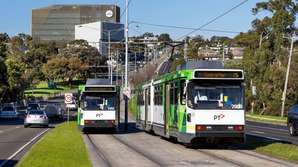
It is defined by Deakin University’s Melbourne Burwood Campus at 221 Burwood Highway, Presbyterian Ladies’ College (PLC) at 141 Burwood Highway, and Mount Scopus Memorial College — three major educational institutions that sit on the same arterial road and define the suburb’s identity. Tram route 75 runs along Burwood Highway directly to Central Pier Docklands.
The median house price was $1,600,000 for the June 2025 quarter (REIV), with 10.24% annual capital growth (CoreLogic). Wattle Park — a 137-acre heritage parkland — and Gardiners Creek Reserve sit on the suburb’s northern and eastern edges. Australia’s first drive-in cinema operated at what is now the Burwood Brickworks site.
Fletchers Canterbury: 250 Canterbury Road, Canterbury VIC 3126 · 03 9836 2222
The first settlement in the Burwood area was surveyed in 1858 and sold as Ballyshanassy. The name changed to Norwood, then to Burwood in 1879, borrowing from a house of that name built by Sir James Palmer in Hawthorn West in 1852. The tram extension to Burwood Highway in 1912 was the catalyst for the suburb’s first significant residential growth.
Postcode 3125 key data:
- 14 km east of Melbourne CBD · Cities of Monash and Whitehorse
- Population approximately 15,147 (ABS 2021 Census)
- Tram route 75 (Burwood Highway, to Docklands); 70 (Riversdale Road)
- Nearest trains: Box Hill (Lilydale/Belgrave), Jordanville (Glen Waverley), Holmesglen
- Major institutions: Deakin University; PLC; Mount Scopus Memorial College
- Shopping: Burwood One (24hr Kmart); Burwood Brickworks; Bennettswood strip
- Parks: Wattle Park (137 acres); Gardiners Creek Reserve
- Original name: Ballyshanassy, 1858 (renamed Burwood 1879)
Fletchers Canterbury: 250 Canterbury Road Canterbury VIC 3126 · 03 9836 2222
What defines Burwood
Most suburbs have a school or a university. Burwood has two elite private schools and a major university on the same highway, served by a tram that runs directly to the CBD. That combination shapes everything about how the suburb works.
Deakin’s Burwood Campus brings approximately 32,000 on-campus students to the suburb. That population sustains the cafés, restaurants, and apartment development that has transformed the Burwood Highway strip over the past two decades. It also drives a rental market that is more active than comparable non-university suburbs.
Quick suburb facts
- Postcode 3125 · Monash & WhitehorseInner eastern Melbourne
- $1,600,000 median house priceREIV June 2025 quarter
- 10.24% Annual Capital GrowthStrong demand trajectory
- Deakin UniversityBusiest campus with ~32k students
- Presbyterian Ladies’ College (PLC)Major independent girls’ school
- Tram Route 75Direct access to the CBD
Burwood property market. 2026 data.
The median house price in Burwood, Victoria (postcode 3125) is approximately $1,600,000 for the June 2025 quarter (REIV). CoreLogic records the rolling 12-month median at approximately $1,507,500, with 10.24% annual capital growth.
The auction clearance rate for houses is 81.1% and average days on market is 29 days (CoreLogic 2026). There were 132 house sales in the past 12 months. The median unit price is $870,000 (REIV, June 2025).
Rental yield for houses is approximately 2.58% with median weekly house rent at $700. Burwood offers a stronger yield than many eastern suburbs due to steady student and professional demand.
The 81.1% clearance rate is not an accident. Burwood’s buyer pool is active and informed. PLC and Mount Scopus families are typically well-researched — they’ve been watching the suburb for months before they bid. When a well-located house within walking distance of either school comes to market with realistic pricing, competition follows.
The Deakin effect is real but often underweighted. Approximately 32,000 students attend the Burwood campus. Many of them rent locally. Some of their parents, doing the maths on rental yield versus the cost of a unit, have been buying investment properties in Burwood for twenty years. No comparable suburb without a university anchor generates that same rental floor.
The 10.24% annual capital growth stands out in Melbourne’s current market. Part of this reflects the Canterbury-Surrey Hills dynamic — buyers priced out of Canterbury ($3.6M median) and Surrey Hills ($2.1M median) are arriving in Burwood at $1.6M and finding the same school highway, the same tram line, and period homes on 600+ sqm blocks.
One highway, three major institutions.
PLC, Mount Scopus, and Deakin University all sit on Burwood Highway. No other suburb in Melbourne’s inner eastern corridor concentrates this much educational infrastructure on a single arterial road.
An Anchor for the Suburb
Burwood’s identity is inextricably tied to the educational powerhouses positioned along its central artery. Deakin University’s Melbourne Burwood Campus provides the volume, bringing thousands of students and faculty daily, fuelling local retail and the rental market.
Presbyterian Ladies’ College (PLC) and Mount Scopus Memorial College provide the prestige and the family buyer depth. Families regularly cross the city—or the country—to be within walking distance of these specific gates.
Connecting all of this is Tram Route 75, directly linking the education corridor to the CBD, ensuring that while the suburb is defined by its local institutions, it remains seamlessly plugged into the rest of Melbourne.
Burwood’s education landscape. The defining drawcard.
Burwood’s education infrastructure goes far beyond standard primary and secondary offerings, driving a unique dynamic in the property market.
Presbyterian Ladies’ College (PLC) at 141 Burwood Highway — founded 1875, one of the first independent girls’ schools in Australia, relocated to the current 16-hectare Burwood campus in 1958. Approximately 1,600 students, ELC to Year 12. Offers both VCE and the IB Diploma.
Mount Scopus Memorial College is a leading Jewish co-educational independent school on Burwood Highway.
Deakin University Melbourne Burwood Campus at 221 Burwood Highway — approximately 32,000 on-campus students.
Government secondary schools include Ashwood High School (the designated zone school) and Camberwell High School. Government primaries include Burwood Heights Primary and Bennettswood Primary. Always verify current catchment boundaries at findmyschool.vic.gov.au.
Presbyterian Ladies’ College
141 Burwood Highway. Relocated to its 16-hectare Burwood campus in 1958. Has offered the IB Diploma since 1990. Named best girls’ school in Australia by The Sun-Herald in 2001.
ELC–12 IB & VCEMount Scopus Memorial College
A leading Jewish co-educational independent school on Burwood Highway. Draws families from across Melbourne’s eastern suburbs, contributing significantly to Burwood’s family demographic.
ELC–12 Co-edDeakin University Burwood
221 Burwood Highway. Approximately 32,000 on-campus students. Built on the site of the former Burwood Teachers’ College (est. 1954). Sustains the suburb’s robust rental and apartment market.
Tram stop 63 Est. 1991Ashwood High School
The designated government secondary zone school for Burwood. Strong academic reputation within the government sector. Well-regarded for its range of VCE subjects and student support programs.
Years 7–12 Zone SchoolBurwood Heights Primary
Government primary school serving the eastern portion of Burwood. Part of a cluster of solid government primaries in the 3125 catchment.
Prep–6 GovtBennettswood Primary
Government primary school serving the Bennettswood neighbourhood of eastern Burwood. The Bennettswood precinct grew post-WWII as the suburb expanded east along Burwood Highway.
Prep–6 GovtGetting around. And where Burwood sits.
- Tram route 75, Vermont South to Central Pier Docklands along Burwood Highway — stops directly outside Deakin University at Stop 63.
- Tram route 70, Wattle Park to Central Pier Docklands along Riversdale Road — northern boundary.
- SmartBus Route 903, Runs via Elgar Road past Deakin; connects to regional bus network.
- Box Hill Station, Lilydale and Belgrave lines, approximately 10 minutes by bus or tram; direct to CBD in approx. 30 min.
- Jordanville & Holmesglen Stations, Glen Waverley line — provides southern CBD access.
- Monash Freeway (M1) & EastLink (M3), Direct access for car commuters to CBD, Mornington Peninsula, and northern/southern corridors.
- North: Riversdale Road and Gardiners Creek — bordering Surrey Hills and Ashwood
- West: Warrigal Road — bordering Camberwell
- East: Middleborough Road — bordering Burwood East and Ashwood
- South: Highbury Road and Gardiners Creek — bordering Ashwood and Glen Iris
- Local government: Split across the City of Monash (southern portion) and City of Whitehorse (northern portion).
- Wattle Park: 137-acre heritage parkland on Riversdale Road; golf course, Chalet (1928), W-class trams, ANZAC Lone Pine memorial.
- Gardiners Creek Reserve: Shared cycling and walking path along the creek; connects to broader trail network.
What Burwood doesn’t advertise about itself.
A suburb with more interesting history than its arterial road suggests.
Australia’s first drive-in cinema was in Burwood
The Skyline Drive-In Theatre, opened at the current Burwood Brickworks site in the 1950s, was Australia’s first drive-in cinema. The children’s playground at Gardiners Creek Reserve is designed as a homage to it.
Deakin University was a daffodil farm until 1951
Albers’ Daffodil Farm operated on the site of the current Deakin University from 1934 until 1951. It became Burwood Teachers’ College in 1954 and was absorbed into Deakin University in 1991.
The suburb was named after a house in Hawthorn West
Burwood takes its name not from the suburb itself but from a house — “Burwood” — built by Sir James Palmer in Hawthorn West in 1852. The original settlement was named Ballyshanassy, then Norwood, then Burwood in 1879.
PLC was one of the first girls’ schools in Australia
Presbyterian Ladies’ College was founded in 1875 at East Melbourne — among the earliest independent girls’ schools in Australia. It relocated to its current 16-hectare Burwood campus in 1958.
The tram on Burwood Highway is what built the suburb
Before the tram extension in 1912, Burwood was agricultural land. The tram triggered residential subdivisions that transformed the farms and market gardens into the suburb seen today.
Australia’s first kindergarten for deaf children opened in Burwood
The Princess Elizabeth Kindergarten for the Deaf opened at 90 Elgar Road in 1950. The site’s history reflects Burwood’s long role as a hub for specialist educational services.
The Burwood Boys’ Home ran for nearly a century
Burwood Boys’ Home, founded in 1895 at 155 Warrigal Road by Robert Campbell Edwards, operated as a residential facility for children at risk from Melbourne’s streets until the late twentieth century.
Wattle Park has two vintage W-class trams
Wattle Park, developed in the 1920s, features two heritage W-class trams as permanent shelters. The Wattle Park Chalet, built in 1928, remains a prominent Tudor-style function venue.
Burwood is divided between two councils
Burwood sits across the Cities of Monash and Whitehorse, a boundary that dates from the suburb’s original municipal divisions, sometimes complicating infrastructure and planning decisions.
The RVIB school ran for over 50 years on Burwood Highway
The Royal Victorian Institute for the Blind (now Vision Australia) purchased 41 acres in 1951 and opened a school in 1959. It operated until 2009 — 50 years of specialist education on a single site.
Burwood from Ballyshanassy to education hub.
Named by a politician, built by a tram extension, and transformed by three institutions that arrived in the same 50-year window.
Ballyshanassy Post Office opens
The first post office opens on 1 May 1853 as Ballyshanassy, named after Sir John O’Shanassy.
First school on Burwood Hwy
A Wesleyan Methodist school opens on the main road, superseded in 1865 by a Common School.
PLC founded in East Melbourne
Presbyterian Ladies’ College is founded at East Melbourne. It relocates to Burwood 83 years later.
Renamed Burwood
The township changes name from Norwood to Burwood, borrowing from a house built in Hawthorn West.
Burwood Boys’ Home founded
Robert Campbell Edwards founds Burwood Boys’ Home at 155 Warrigal Road, a landmark welfare institution.
Tram arrives
The Toorak Road tramline extends to Burwood Highway, triggering residential subdivisions and growth.
Wattle Park Chalet built
The Chalet is constructed in Tudor architectural style within the 137-acre Wattle Park reserve.
Albers’ Daffodil Farm
Albers’ Daffodil Farm begins operating on the site that will eventually become Deakin University.
Drive-in cinema & Deaf kindergarten
The Skyline Drive-In Theatre and Princess Elizabeth Kindergarten for the Deaf both open.
Burwood Teachers’ College
The government opens Burwood Teachers’ College on the former daffodil farm site.
PLC relocates to Burwood
PLC moves to its 16-hectare campus, establishing the education corridor.
Deakin University
The merger of Victoria College into Deakin University brings the Burwood campus under the Deakin name.
Institutions and people that shaped Burwood.
Burwood’s notable history is less about individual residents and more about the institutions that chose this suburb — and kept choosing it across 150 years.
Presbyterian Ladies’ College
One of the first independent girls’ schools in Australia. Named best girls’ school in Australia by The Sun-Herald in 2001. PLC’s presence is the single most cited reason families give for choosing Burwood as a place to live.
Deakin University
Approximately 32,000 on-campus students. Named after Alfred Deakin, Australia’s second Prime Minister. Rated #1 Victorian university for graduate employment. Its presence sustains Burwood’s rental market.
Mount Scopus Memorial College
A leading Jewish co-educational independent school that draws families from across Melbourne’s eastern suburbs, contributing to Burwood’s education corridor.
Australia’s first drive-in cinema
The Skyline Drive-In Theatre operated at the current Burwood Brickworks location. The children’s playground at Gardiners Creek Reserve is a direct homage to this piece of local history.
Burwood Boys’ Home
Founded 1895 by Robert Campbell Edwards. One of Melbourne’s earliest institutional child welfare services, operating for nearly a century as part of Burwood’s civic character.
Wattle Park Chalet
Built 1928 in Tudor architectural style. A heritage-listed function venue for weddings, events, and community gatherings set within the 137-acre Wattle Park reserve.
Everything people ask about Burwood.
Every answer is complete, sourced, and matches the FAQPage schema in this page’s header.
The median house price in Burwood, VIC 3125 was $1,600,000 for the June 2025 quarter (REIV via Fletchers). CoreLogic records the rolling 12-month median at approximately $1,507,500, with 10.24% annual capital growth. There were 132 house sales in the past 12 months. On average, houses spend 29 days on market. The median unit price was $870,000.
Burwood is home to Presbyterian Ladies’ College (PLC) at 141 Burwood Highway — founded 1875, one of the first independent girls’ schools in Australia. Mount Scopus Memorial College is a leading Jewish co-educational independent school. Deakin University’s Melbourne Burwood Campus is at 221 Burwood Highway.
Government secondary schools include Ashwood High School (the designated zone school) and Camberwell High School. Burwood Heights Primary and Bennettswood Primary are the key government primaries. Always verify catchment boundaries at findmyschool.vic.gov.au.
Deakin University’s Melbourne Burwood Campus at 221 Burwood Highway is the university’s busiest campus, with approximately 31,975 on-campus students (2020). The site was previously Albers’ Daffodil Farm, established 1934, which operated until it was sold to the government in 1951 and became Burwood Teachers’ College in 1954. That college became part of Deakin University following the Victoria College merger in 1991. The campus is named after Alfred Deakin, second Prime Minister of Australia.
Tram route 75 runs along Burwood Highway, connecting Vermont South and Central Pier Docklands, stopping directly outside Deakin University’s Burwood Campus at Stop 63. Route 70 runs along Riversdale Road along the suburb’s northern boundary. The tram on Burwood Highway was extended to the area in 1912, which was the catalyst for the first major residential development in Burwood.
Wattle Park is a 137-acre public park at Riversdale Road, Burwood. It features walking tracks, a nine-hole public golf course, children’s playgrounds, BBQ facilities, public tennis courts, and the heritage Wattle Park Chalet — a Tudor-style building from 1928 used as a café, tea house, and function venue. The park holds two heritage W-class trams as shelters and is home to a Lone Pine ANZAC memorial. It is adjacent to the Gardiners Creek Reserve cycling and walking trail.
Burwood has a median house price of $1,600,000 (REIV, June 2025 quarter) with 10.24% annual capital growth (CoreLogic). The suburb offers direct tram access to the CBD, two prestigious private schools (PLC and Mount Scopus), a university campus, the Burwood Brickworks and Burwood One shopping centres, and proximity to Wattle Park and Gardiners Creek. Rental yield is approximately 2.58% for houses, driven partly by Deakin University students. Contact Fletchers Canterbury on 03 9836 2222 for a complimentary appraisal.
Burwood Brickworks Shopping Centre is a sustainable retail development at Burwood Highway. Built on the site of former brickworks, it features specialty stores, fresh food markets, an Asian grocer, Acre Farm and Eatery, a cinema, health and wellness facilities, and is developed by Frasers Property. Adjacent to the centre, Gardiners Creek Reserve’s Skyline Drive-in Playground is an homage to Australia’s first drive-in cinema, which operated at this precise location in Burwood in the 1950s.
Burwood is 14 km east of Melbourne CBD. Tram route 75 on Burwood Highway runs directly to the CBD (Central Pier Docklands), taking approximately 40 minutes. Route 70 along Riversdale Road also provides CBD access. The nearest train stations are Box Hill (Lilydale/Belgrave lines), Jordanville (Glen Waverley line), and Holmesglen (Glen Waverley line). The Monash Freeway (M1) and EastLink (M3) provide car access.
The first settlement in the Burwood area was surveyed in 1858 and named Ballyshanassy, after prominent politician Sir John O’Shanassy. Five acres were set aside for what is now Burwood Cemetery. The name changed to Norwood and then to Burwood in 1879. The name Burwood itself came from a house called Burwood (later Invergowrie) built by Sir James Palmer in Hawthorn West in 1852. The post office opened as Ballyshanassy on 1 May 1853 and was renamed Burwood around June 1879.
Burwood has a median house price of $1,600,000 (REIV, June 2025), compared to Canterbury’s $3,687,500 and Surrey Hills’ $2,100,000. Burwood offers more affordable entry to the inner eastern corridor with direct tram access, two major private schools on the highway, and Deakin University on the doorstep.
The school zone story is different — Canterbury and Surrey Hills both have the Canterbury Girls Secondary College zone; Burwood’s catchment schools are Ashwood High School and Camberwell High School at the government level. The private school story (PLC, Mount Scopus) is the stronger buyer driver in Burwood.
Burwood and surrounds.
Burwood borders several of Melbourne’s most active eastern suburbs property markets.
Thinking of selling in Burwood?
The Fletchers Canterbury team covers Burwood and the surrounding eastern suburbs. Complimentary appraisal, no obligation.
Data sources: Woodards/CoreLogic (clearance rate 81.1%, 132 house sales, 29 days on market, 2026); REIV via Fletchers (median house price $1,600,000, median unit price $870,000, June 2025 quarter); CoreLogic (12-month median $1,507,500, 10.24% growth); ABS 2021 Census (population, demographics); Wikipedia, eMelbourne, Wikipedia — PLC, Wikipedia — Deakin (historical data). Published May 2026 · Last updated 8 May 2026 · fletcherslocal.au/suburb/burwood